Showing posts with label digital mapping. Show all posts

Thursday, 21 October 2010

Where's the path


Many thanks to teacher advisers in Stockport for showing me this website.  This is a fantastic site if you want to compare a map and aerial view.  View `Where's the path' >>>

Friday, 2 April 2010

Open Data: new map site from the Ordnance Survey


The Ordnance Survey has now made some of their map data freely available for viewing, download and embedding into other web projects.

You can read more about this project on the Guardian website >>>>

I've had a very quick look this afternoon and I'm not totally sure how useful I'll find it - though it may be too early days yet.  I started with Street View,  a very attractive street map, which I've used very successfully with children during the OS/BECTA  map pilot for schools. The map displays very quickly but in a long narrow band which restricts visibility.


I tried downloading the SE grid square (100k square) and as this turned out to be 800+mb in size I quickly stopped downloading on my very slow broadband connection.

I'm sure that I need to give this website a little more time yet but as I can access OS 1:25000 and 1:50000 maps via BING maps (and these display at full screen size) I'm not entirely sure what use I'll make of the OS map data yet.

For secondary schools however, OS has made available different data sets which will work with GIS software which should make obtaining this data much easier than at present. 

Saturday, 20 March 2010

Where in the World?


An excellent example of children using Google Earth to explore the Amazon Rainforest appears on `Techno Stories'

Bev writes, `On this occassion we were using Google Earth as a research tool using the ‘Global Awareness’ layer to investigate websites and organisations with links in this area.'  Read the blog post to find out more >>>>

Saturday, 6 March 2010

Young Geographers Go Local

A new set of resources to help you teach about your `Local Area' is now available from the Geographical Association website.


There are lots of ideas here to help you get started with using ICT and digital mapping in the context of your school grounds and local area.  I chose to focus on how children `felt' about their local area in order to engage them directly with their `everyday geographical experience'.  Please don't be put off by the `online cpd' label on the GA website - these are all practical ideas that have been shared elsewhere on this blog.

Access this resource at: Young geographers Go Local

Sunday, 20 December 2009

UK Snow - track the current snow storm in the UK


I've been fascinated by a website that uses a Google map to track the current snow in the UK. You can help to track the course of the snow as it crosses the UK by posting to Twitter.

Click on the link to be taken to >>>> UKsnow

Saturday, 3 October 2009

`MapIT Picture IT Write IT' seminar at the 2009 TES Education Show in London


It was really good to meet everyone at my seminar session at Olympia yesterday and absolutely fantastic to meet so many people who are enthusiastic about geography. I've updated the PowerPoint and credited photographers & schools where appropriate. I'll send everyone who left me their e-mail address a copy of the PowerPoint (probably later this week) and I'll also be sending you an invitation to join the Primary Geography Champions NING - though if you don't want to wait you can click on the link above and register today. If you'd like to contact me directly my contact details are on the Geographical Association website.

The PowerPoint has been split into two halves to make the download size more manageable:

Monday, 18 May 2009

Dual Maps


Dual Maps is a stunning combination of StreetView Google Maps and Virtual Earth. Thank you to Noel Jenkins for sharing this website. I think it's great!

Saturday, 18 April 2009

Mapping Images the Digital Way

I'm sharing the presentation that I created for my workshop at our recent conference in Manchester. My aim when preparing the presentation was to create slides with links to other useful web-sites and to provide one or two `how to ...' sections. These include `How to locate images that have been shared under the Creative Commons Licence' on Flickr' and a slightly updated version of creating a `Google My Map'.

Monday, 13 April 2009

Getting ready for the GA Conference in Manchester

I've just about completed my presentation for the Geographical Association Conference in Manchester (17th - 18th April).

I'm running a session called `Mapping Images the Digital Way' as an introduction for teachers to the use of online image galleries and online mapping. The central aim is to create a `My Walks' map using Google `My Maps' and to introduce the Northumbria University website called My Walks.

I'm currently experimenting with the integration of the Google suite of programmes and this post is a result of `clicking on' the Blog link at the bottom of the Picasa 3 editing page. I think Picasa is one of the best of the free photo-editing tool and it now comes with some great new features, for example a simple tool to create a video from still images. Because it is so straightforward to use I will be recommending it for simple editing projects in the classroom.

As the focus of the session is on creating digital maps to display the location of photographs I will be demonstrating how easy it is to drag images from the online gallery onto the online Google Map. I intend to use my Dartmouth collection to demonstrate how easy this is.
Posted by Picasa

Sunday, 29 March 2009

Silvepura a village in India

I'm slowly trying to sort out my ideas and thinking about my visit to India. I've begun to add images to my Flickr India gallery.

As someone who likes to be able to locate places on maps one of my first activity has been to build a customised map of the locality of Silvepura using Google `My Maps' which you can see on the left. (Click on the link above to be taken to the website.) This is a work in progress and I intend to keep adding images to this and possibly some short personal `stories' too.


Cat and Caroline wrote a`blog' for the children in their school while we were still in India which gives a wonderful sense of our visit.

I kept a journal while we were in India and I'm slowly adding some of my journal entries to my other blog site, Primary Geography.

Originally I set this second site up because I wanted to learn how to use Edublogs. I think Edublogs is probably a more trusted site for use with children I decided to use this site as a way of sharing my experiences of people and places around the world and hope some of the ideas and entries might prove valuable.

Wednesday, 3 December 2008

Tom Barrett's Blog - Using Google Earth to plot the journey of James and the Giant Peach


Thankyou to Alan (my colleague at the GA) for sharing information about this blog at our meeting yesterday.

Tom has been doing some amazing work with his class on using Google Earth to plot the story of James and the Giant Peach. Start with his final page of the story and then choose the links to work back.

He has also been using Vocaro to record children's voices - which were then embedded into Google. Please read his blog to find out more.


Thursday, 4 September 2008

Geograph: an image for every square kilometre in the UK

We’ve had a really good August at home this year walking local footpaths and finding places that we’ve never been to before, all within a 5 mile radius of home. The motivator for all of this activity has been the Geograph website.

If you are not familiar with the site, then the aim of Geograph is to collect photographs for every square kilometre within the UK. 88% of England, Scotland & Wales now have at least one photo per kilometre square and 22% of Ireland has been covered.

This is a really useful website if you need images of the UK, first because all images are shared under the Creative Commons License (this means that although the photographer owns the copyright they have agreed to other people using their images). Second because the images are a reasonable size (640 pixels wide) they are very useful for projecting on an interactive whiteboard. So forget those tiddly little snippets that you find through searching Google Images – most of which are covered by copyright – and nearly all of which are useless for projecting and start exploring Geograph.

So log-on to their website: www.geograph.org.uk

Choose a place – it’s not very good at recognising postcodes – so either the place name or a four figure Grid reference work best.

If you want to see where I’ve been walking, then you could start in the west on the Moorland above Langsett ( SE1800 in the search box or http://www.geograph.org.uk/gridref/SE1800 should take you directly there) and try working your way east towards the M1 motorway.

Monday, 4 August 2008

Creating a `My Walks' Map using Google Maps

Several posts ago I provided a Slideshare PowerPoint to show how to use Quikmaps but I never got round to publishing a `How to create a map using Google My Maps'.

Google `My Maps' uses the Google Maps website as opposed to the downloadable `Google Earth' - so there is no need to download anything to your computer.

It is easy to add images into the hotspots that you create as long as your images link to a photo that is stored online, for example on the Geograph website or perhaps on Flickr or Picasa.

Follow the instructions on the presentation to learn how to create your own illustrated maps.

Create a map using Google `My Maps'
view presentation (tags: online mapping tags digital ict)


Additional guidance is available from Google

Monday, 5 May 2008

The Ordnance Survey & Becta schools map pilot

The Ordnance Survey (OS) and Becta have been running a `map pilot' aimed at exploring ways of making digital maps accessible to schools.

The introduction on the E-map site reads:

`The MapPilot enables a range of Ordnance Survey digital mapping to be accessed free by pilot schools and educational mapping suppliers for a trial period. MapPilot is run by Becta, in conjunction with The Advisory Unit: Computers in Education and eMapSite with funding from DfES and support from Ordnance Survey.'

I'm currently registered with the map pilot in conjunction with Methodist J & I and I've finally got around to downloading some maps from the site and using them in conjunction with the software programme `Local Studies'.

The map I chose to use was the `Streetview' map of Wakefield, which was unknown to me before I became involved in the project. It is simple and clear and allows some additional information to be added to the map (via a simple GIS such as Local Studies) without appearing too cluttered and illegible.

We have used a `Streetview' map of the south side of Wakefield city to record our `Top Ten Places in Wakefield'. We also used images downloaded from the Geograph website to populate the hotspots.

`The Geograph British Isles project aims to collect geographically representative photographs and information for every square kilometre of Great Britain and Ireland.'

This is the first opportunity that the majority of the children in the class have had to link data to locations on a Wakefield map (as opposed to maps of the school grounds) and I have been delighted to find out how well many of the children can do this.

The PowerPoint embedded below illustrates work that we undertook during week 6 & 7 of my visits to the school. The children are now fairly accomplished users of Local Studies and the staff in the school like the programme.

(Though I'm still not convinced that I would recommend the software to schools in future as my feeling is that the software company is not keeping it sufficiently updated and compatible with modern school networks.)


Sunday, 4 May 2008

Using `Local Studies' the story continues ...

I've just undertaken a further 3 weeks of work with Year 5 pupils at Methodist J & I, Wakefield. The children needed an opportunity to re-cap and remember how to use the programme. So during the first week of my visit we went back to drawing a map using the programme tools.

I was able to show them a few examples of work about the `local area' that had been undertaken in other schools. They were particularly interested in hearing that Year 1 at Shelley Primary School near Huddersfield had been using `Quikmaps' to record what happened in their village and additionally pleased to know that their own example had been the inspiration for other schools.

The PowerPoint in this post shows the work we started on the 16th April (after a gap of 4 months). I was really interested in the different styles of maps that the children had drawn and this PowerPoint is more of an exploration of what the children did, rather than `how to do' Local Studies.

Saturday, 3 May 2008

Do you use online mapping to locate places? If so which ones?

The current round of voting has now closed. Nineteen people have registered their vote so far – which is pleasing because I recognise that this is a relatively unknown blog.

As might be anticipated Google Maps and Google Earth have achieved the highest scores (though only just) and Multi-Map is perhaps beginning to lose out. This overall score reflects my own current use of online mapping as I much prefer Google Maps to the re-vamped version of Multi-map.

One programme that is well worth a look is the Microsoft website, variously known as Live Local, Maps Live etc. This has not scored as well as Google maps yet for some parts of the country the satellite views are far more detailed than on Google Maps.

The current edition of Web User Magazine 24 April – 7 May 2008, Issue 186 (which I think is excellent), devotes 2 pages to getting the most from `Live Search Maps’, pp. 62-63

www.webuser.co.uk

Wednesday, 2 April 2008

Geographical Association Conference

Life has been very busy during the last month so it's almost a month since I lasted shared anything through this blog.

I've just returned from the annual Geographical Association Conference which was held in Guildford this year. It was attended by over 700 people and the overwhelming feeling is that the conference was a real success. Kate Russell and I ran a workshop on behalf of the ICT working group with thirty + enthusiastic geographers attending. Our message to the group was that we need to extend the use of online mapping in the primary classroom. I was able to provide an overview of the work I've been doing with the Y5 class on using Local Studies and Quikmaps. see the embedded PowerPoint below:


Find out more about the conference presentations at:
http://www.geography.org.uk/events/annualconference

See below for a quick guide to creating a personalised map using Quikmaps

Saturday, 8 March 2008

Please Keep Voting + some new websites

Please can I say a very big thank you to people for voting for the web based map programme that they use. I'm finding this really helpful - so anyone who reads this who hasn't yet voted please can you do so.

I've been exploring two websites that are totally new to me this morning and one that I've seen before but haven't used much.

The first one is a mash up of Google Maps and Flickr called Flickrvision
This shows the latest images posted to the Flickr website over a Google Map. Choose the 3D view and you see a view of the Earth from space. This is fantastic because it shows which parts of the globe have night and which day. It's quite fascinating to see images pop up from different parts of the world.

The second is called WalkJogRun
and enables you to trace a route on a Google Map. It measures the distance, records your route and tell you how long it will take you to complete the journey depend on your speed of travel. Great for walkers and runners but also very useful for route planning activities in the classroom.

The third programme is called Flash Earth and allows you to view your chosen location via a number of different online mapping programmes. Add a comment after this post to let me know if you have found any of these websites useful.

Saturday, 1 December 2007

Emoting with maps!

The emoticon icons used with the Local Studies programme were drawn by the children and then re-created using the programme Symbol Draw. Unfortunately this programme (or at least the version I possess) is feeling a little dated now and I was unable to import pre-scanned images. Instead I had to re-draw each symbol using the simple draw tools provided in the programme.
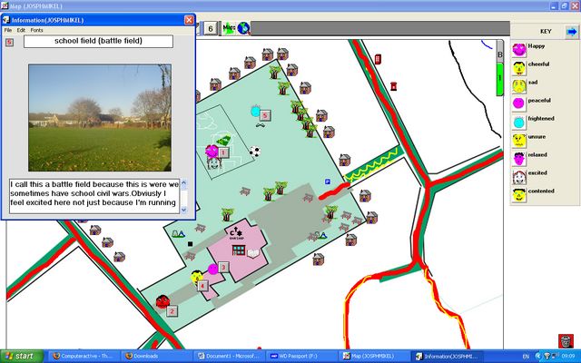
My next step will be to explore using the children's icons with Google `My Maps' as I know it is possible to import new icons from scanned jpeg files into it.

Emoting with maps!


I’ve just completed my fourth and final session of the Autumn Term with Year 5 at Methodist J & I. This week we learnt how to add text to their Local Studies map and how to add the hotspots which display text and pictures.

One of my aims for this project has been to try and tap into the children’s `geographical imaginations’ by providing them with an opportunity to express how they feel about different parts of the school and grounds.

Well worth reading is an article entitled `Emoting with maps!’, which was written by Diane Swift for Issue 27 of the Ordnance Survey Mapping News. Diane argues convincingly that we should be using mapping as means of exploring the personal geographies inside children’s heads.

“If this geography remains in the head of the learner, it is an educational opportunity lost. If pupils’ geographical imaginations do not find a forum within which they can be shared, developed, refined, critiqued and reviewed, misconceptions may go unchallenged and pupils’ learning become restricted in certain ways. ... Using maps and cartography is one medium into which emotions can be poured. Annotating conventional maps or creating the pupils’ own maps are purposeful activities. Through these activities the geography in our heads, our emotional geography, is revealed. Once revealed it can be used, analysed, and reviewed.” Diane Swift, (2004) p.12, Mapping News Issue 27 Winter 2004, Ordnance Survey

The majority of children have now completed their Local Studies maps. Use of the Local Studies programme has enabled the children to represent their school grounds and the immediate local area creatively and imaginatively. Not only are their maps a real pleasure to look at they are also highly informative about what it `feels’ like to be in certain places. As I write this I’m left wondering about the extent to which some of these messages will prove to be a revelation to the staff of the school.

“… exploring a representation, constructing an argument using cartography is challenging and yet accessible to all. My own children in their reception and pre-reception classes are well used to the happy and sad face in their classroom. Their names are places on the face that best shares the teacher’s view of their behaviour. They can then transfer these familiar symbols, with relative ease, to a simple map or photograph to explain their geographical imagination of a place. Happy is, of course, used to symbolise the treasured places. This map is then used as a resource to support an informed conversation as to why they hold that view of that place, and to see if that view is shared. From there we explore if that view is reasonable, and if not gently challenge the perspective with reasoned alternatives, using geographical information. Through conversation geographical thinking is being refined and the quality of this thinking is raised.” Diane Swift, (2004) p. 14