


 PrimaryPete (Twitter @primarypete_) has produced a set of very helpful videos on using Web2 technology. The link is to his tutorial on using Etherpad - he also has videos on how to use Photostory3, Wordle and a whole host of others - why not check him out.
Wednesday, 30 December 2009
Video tutorials for Web2 applications - including Etherpad
PrimaryPete (Twitter @primarypete_) has produced a set of very helpful videos on using Web2 technology. The link is to his tutorial on using Etherpad - he also has videos on how to use Photostory3, Wordle and a whole host of others - why not check him out.
Updating my Flickr pages with images stored on my computer

I've been spending some time over Christmas adding images to Flickr. I've got thousands of images stored on my computer (most of which are backed up elsewhere).
Apparently there are now more digital photographs in the world than house bricks!!
You can view my latest updated images within the Flickr badge at the top of the left column. This provides a direct link to my Flickr pages.
Tuesday, 29 December 2009
Chembakolli - a village in India

We used drama, sense impressions, art, creative writing & data handling to help year 3 & 4 children to gain a sense of what it might be like to live in ` A Village in India'. Originally taught in 2002, this geography unit set out to embrace citizenship, art & drama and speaking & listening which fit very well with the broader approach to developing a `creative curriculum'. I created a website to share resources (though some of the pictures that I sourced from the internet are now looking very dated). The activity plan for the unit can be downloaded from the website.
I've now provided an update for this unit by creating a chart to show where the learning acitivities fit into the >>>> (click on the red text) New Primary Curriculum (NC 2011).
You can download this from here.
Silvepura - A village in India
Silvepura is small village in Karnataka State, 28 kms NW of Bangalore, India. It is a largely Christian village which is unusual for this part of India. I've just been creating cpations for a new photopack for India that will be available in the New Year from the Geographical Association. It felt really good to re-visit these images and to be reminded of our very special visit to India.
Tuesday, 22 December 2009
CABE: Education grant winners 2009-10
At the end of 2009, six schools were awarded CABE education grants of £1,500 to support imaginative teaching about architecture and the built environment.
- Frank Barnes School for Deaf Children, London
- Pewley Down Infant School, Guildford
- St Augustine’s Catholic Primary School, Gateshead
- Virtual School for Children in Care, Cornwall
- Ercall Wood Technology College, Telford
- Haringey Sixth Form College, London
CABE is the government’s advisor on architecture, urban design and public space.
If you haven't come across them before their RESOURCES are well worth a look as most are FREE.
Monday, 21 December 2009
Christmas Greetings
Christmas looks like being a white one for us this year. It snowed quite a bit on Sunday afternoon and then cold weather (from continental Europe) looks like keeping the temperature around freezing. I've been experimenting with some publishing software called ISSUU which I think is great. Christmas Greeting to all.
Ideas for using images
Lots of good ideas for using images in this Google presentation - though not all of these ideas are focused on geography (a few are) many to them can be adapted. Why not share some of your own ideas and help to build this resource. It was started by Anthony Evans of Redbridge LA. He'd welcome your ideas too!
Sunday, 20 December 2009
UK Snow - track the current snow storm in the UK

I've been fascinated by a website that uses a Google map to track the current snow in the UK. You can help to track the course of the snow as it crosses the UK by posting to Twitter.
Click on the link to be taken to >>>> UKsnow
Tuesday, 15 December 2009
West & South Yorkshire Primary Geography Champions
As the new Primary Geography Champion for West and South Yorkshire I am very keen to develop networks of teachers who can share creative ideas for geography.
The Primary Champions have been recruited from across England and support primary geography through an online Networking site or NING.
There are lots of good ideas for teaching primary geography on this site already. People share ideas in the form of `blogs’ which appear on the home page and there are some particular contributors that I would highly recommend you follow. My favourite being the The Hampshire Primary Geography Network which is run by Sharon Witt.
I’ve now set up a group page for West & South Yorkshire.
See the full flyer below. Click on the page (and then again if you want to enlarge further).
Saturday, 12 December 2009
The Story Of Cap & Trade
I have lots of personal reservations about leaving carbon management in the hands of big business. This US video explains the process in a way that makes sense to me though I'm not sure everyone would agree.
What do you think?
The Story of Cap & Trade from Story of Stuff Project on Vimeo.
What do you think?
Friday, 11 December 2009
`Copenhagen Climate Conference' - at what age should we start to focus on `climate change' with primary aged children?

Climate Change is very much at the forefront of everyones mind at the moment and we've been thinking about what we have available on the GA website to support primary teachers. Not much is the simple answer. While searching the web I came across a very interesting article by Leo Hickman in the Guardian. Why don't we stop hurting the planet?
Leo has just written a new book called, `Will Jellyfish Rule the World?'
As I find suitable website I'm starting to list them on Twitter - see bottom left column of this website or on Twitter @primarygeog
Tuesday, 8 December 2009
Who Do We Think We Are? Week 21st – 27th June 2010 Exploring Identity, Diversity and Citizenship

Who Do We Think We Are? Week 2010 - Grants for Schools Now Open
Grants of up to £500 are available for schools to develop activities linked to the ‘Who Do We Think We Are?’ Week programme for 2010 (www.wdwtwa.org.uk).
Who Do We Think We Are? is an annual programme of advice and curriculum support that helps schools explore the issues of identity, diversity and citizenship at the local and national scales through four key themes:
• School and community
• Relationships, belonging and faith
• History and settlement
• Britishness, national identity/values and the 2012 Games
The programme culminates in a national week of events and activities taking place in the week of 21st – 27th June 2010. During 2009, the project awarded 10 grants to maintained schools across the English regions to develop activities. Projects explored issues of identity, diversity and citizenship, involved students and people of all ages, across many diverse British communities and served to highlight the ties that bind us together in our local communities and nationally.
As part of ‘Who Do We Think We Are? Week’ 2010, schools are again being offered the opportunity to apply for grants of up to £500 to develop activities linked to the focus week. Further details of the application process can be obtained by visiting: http://www.wdwtwa.org.uk/news/1536/grants-for-schools-now-open.html. Applications will be accepted until 12th February and should be submitted to the Project Officer at wdwtwa@rgs.org .
Friday, 30 October 2009
Finding high quality images for geography
I prepared this PowerPoint for my seminar at the TES Education Show in London (02/10/09) and then decided that I didn't have time to share it - so I've chosen to share it here instead.
Photographs for geography
View more presentations from Geoprimary.
Tuesday, 27 October 2009
Flip Flotsom - exploring the idea of sustainability through the journey of the humble flip-flop in Kenya

I've just come across this poem and video on YouTube (though you may know it as it's been around since at least 2003). I think both are wonderful - the poem and video are lyrical explorations of what happens to a `flip-flop' from the time it is manufactured to the time it is recycled.
Flip Flotsam
This is the beach
where the flip flops come
at the end of their
flip flop trip.
And where does a
flip flop trip begin?
the floor of a flip flop factory;
on the shelf of a flip flop shop;
or the foot of a flip flop fan?
See Elspeth Murrays website for a full version of the poem (and lots more too!) She sounds really great and has done lots of work in schools.
You will find the video on You Tube
This video is also available from Jouneyman Pictures who have lots of documentary videos available to support geography though not all are suitable for primary children.)
Wednesday, 21 October 2009
50 plus Creatively Simple Ways to Teach Primary Geography
Following in the footsteps of Tom Barrett and Tony Cassidy I've started a collaborative Google Presentation. The idea behind this is that people with an interest in sharing ideas for Primary Geography work together to pool ideas. SO I NEED YOU TO SHARE TOO! There are two ways you can do this - preferably you send me your e-mail contact address and I add you as a collaborator so that you can edit the Google Doc. If you don't feel very confident about this then please send me your idea and I will add it myself. I'd like this to be a collaborative endeavour - please contribute. e-mail: wnorth@geography.org.uk
Friday, 9 October 2009
Primary Geography Champions
Visit Geography Champions
Why not join us on the site - we're trying to establish this network to support teachers in the UK and beyond.
Saturday, 3 October 2009
Map IT Picture IT Write IT - Course Handouts

Course handouts and the City of the Week powerpoint that were shared at my seminar (see next post below) can be accessed via the following links:
Download Course Handouts below:
1. MapIt PictureIt WriteIt - website guide
2. A Guide to creating maps using Quikmaps
3. Conversations between characters `At the skatepark'
4. A Different View:Images and Activities
5. Four senses frame (see, hear, smell, feel or touch)
6. What's in the square (Nine Number Grid)
7. City of the week PowerPoint Presentation You will need to download this presentation from the Slideshare website in order for the links to work.
`MapIT Picture IT Write IT' seminar at the 2009 TES Education Show in London

It was really good to meet everyone at my seminar session at Olympia yesterday and absolutely fantastic to meet so many people who are enthusiastic about geography. I've updated the PowerPoint and credited photographers & schools where appropriate. I'll send everyone who left me their e-mail address a copy of the PowerPoint (probably later this week) and I'll also be sending you an invitation to join the Primary Geography Champions NING - though if you don't want to wait you can click on the link above and register today. If you'd like to contact me directly my contact details are on the Geographical Association website.
The PowerPoint has been split into two halves to make the download size more manageable:
Map It Picture It Write It Part 1
View more presentations from wendyn57.
Map It Picture It Write It (Part 2)
View more presentations from wendyn57.
Saturday, 15 August 2009
Japanese Anenome, Garden August 2009
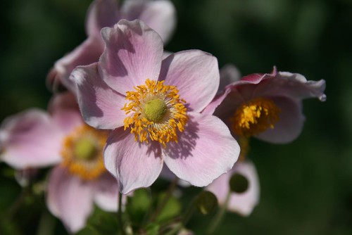
I'm taking a well earned rest from geography for a few weeks over the summer. I've been experiementing with close up flower shots in the garden. I thought it was time that I used a few different settings on the SLR rather than using it in program mode all of the time. I was quite pleased with some of these images so I've added them onto my Flickr site.
Saturday, 25 July 2009
Starting with geography: using picture books to plan an integrated topic in the primary school
If you are looking for alternative starting points for planning an integrated topic in the primary school – then a picture book could provide a very accessible way in. I think this particular book could provide a starting point for Year 2’s (6-7 year olds) to Year 4 or maybe even Year 5 (8 – 10 year olds).
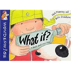
First the book that you choose has to have a strong geographical theme running through it. My chosen book, `What if …’ is about recycling so it fits very nicely into the theme of ESD (Environment & Sustainable Development). This is a theme that is shared equally strongly with science and also with citizenship. So we have a very good basis for a geography/science/citizenship integrated topic.
Now I realise that all over the land in the world of the English primary school the words `we’re delivering a skills based curriculum’ are currently `hot’ but I want to argue here for thinking about concepts. We need to start with the `big ideas’ of a subject.
I want to start by explaining how to do this where geography is the lead subject. First I developed a planning grid of empty boxes with headings that focus on both geography’s `big ideas’. In terms of `big ideas’ I want to highlight PLACE, SPACE & SCALE as being the most important for primary geography though you’ll notice in my planning grid that I’ve linked together `place & scale’ and then `location & space’. On the exemplar sheet I’ve prioritised `environmental interaction (including ESD)’ as this is essentially what the book is about. Though I’ve also included `interdependence & connectedness’ – two very important ideas that were largely neglected in the current English National Curriculum programmes of study for geography, and then `changing human & physical processes’ and `cultural understanding & diversity’. On the blank planning sheet I have left the boxes under `curriculum links’ blank. Though as I read through the text of `What if …’ I realised that the book also embraced art, science and citizenship – so I added these headings onto my sheet.
So how did I use the planning sheet?
First I read through the book and listed all of the ideas that the book suggested to me. These are in black type.
Next I looked at these ideas and though about `activities’ and the kind of ideas that might be developed into activities and I listed these in blue type.
I haven’t done the next stage – but what I would do next is to choose three or four of these ideas/activities and develop them into an outline for a medium term plan.
If anyone uses this idea and adapts it for use with their own class I’d love to hear how it goes. Please add a comment or get in touch by e-mail. You’ll find contact details on the Geographical Association website.
Friday, 24 July 2009
Using picture books to develop geographical ideas
When teaching an integrated curriculum it is important to understand how the `big ideas’ from different curriculum subject or area can contribute the developing children’s understanding of the world.
Place space and interconnectedness are three of geography’s `big ideas’. Here they are used in conjunction with `key questions’ to help you plan the geography component of a study starting with a picture book that has a strongly geographical theme.
Starting from Picture Books – The Sea and Coast
Approaching curriculum planning with GEOGRAPHY and CREATIVITY in mind:
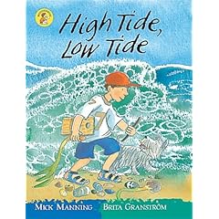
- Use the books to provide you with the outline plan for a short or medium term unit. Three books that could provide a useful starting point for a KS1 & lower KS2 link ENVIRONMENT & SUSTAINABILITY through GEOGRAPHY & SCIENCE.
- One World, Michael Foreman 0-09-983480-4
- High Tide, Low Tide, Mick Manning & Brita Grandström 0-7496-4181-9
- The Rockpool, David Bellamy & Jill Dow 0-7112-1386-0
- Use the book in conjunction with an outline planning frame to identify key learning concepts that will be the focus of work with your class. An exemplar frame has been provided for `What if? (Mick Manning & Brita Grandström)
- Decide which are the two/ three most important geographical concepts listed on the frame. These will form the basis of the children’s learning so highlight them. Do the same for other subjects. The time that you are able to devote to this unit/project will influence your choice.
- Identify additional resources that will help you provide more in-depth learning in relation to identified concepts.
- Plan activities to support learning.
WHOLE SCHOOL PLANNING
To ensure whole school continuity and progression you will need to identify where key geographical concepts will be taught by each class in school and map this onto your whole school plan.
Friday, 17 July 2009
Making Geography Happen

The photograph that forms the new banner for this blog was taken at a recent meeting of the `Making Geography Happen' group. This project, set up by the Geographical Association, involves teachers from two secondary schools and three primary schools. The teachers involved have been devising and teaching geography themes designed to motivate learning and to demonstrate how good teaching `can make geography happen' in classrooms.
To find out `what works' the teachers have involved their pupils in the evaluation. They have also been looking at what things help children progress in their geographical understanding.
I particularly liked this Year 7 (11-12 years) project on `The school of the air' in Alice Springs. One very motivational element of the project was the final presentation where pupils were encouraged to present their `reflection logs'in any way they chose. There were crocodiles with tongues that unravelled to show the logs. Rugby balls that opened up and even a `shopping trolley'.
Ideas and resources from this project will form a new section of the Geographical Association website. I'll put up a new post when the project goes online.
Thursday, 21 May 2009
Nelamangala Market
We visited the market during our visit to Southern India in February this year. (This is a my experiment to find out what happens when I embed a Flickr slideshare into this blog.)
Monday, 18 May 2009

Saturday, 9 May 2009
A new photo pack for Chembakolli

Action Aid recently published a new photo-pack for Chembakolli: Life in an Indian Village.
This is definitely the best photo-pack of the village to date. I really like the way that the writers of the pack have chosen to combine a full sized photograph on one side of a card with information and photographs on the reverse as this really helps us to see `the story' behind the picture. Something that I feel is crucial element of any resource on distant place.
I usually look at the photographs in a pack with a fairly critical eye, even more so since my recent visit to Southern India. The photographs in this pack are of good quality and show very positive images of the people who live in the area. These photocards also raise a number of issues about the lives of people in the village which could usefully be explored using a 'Philosophy for Children' approach. If you are still using the original pack and want to continue to teach about village life in India, then this pack is very worth considering.
You can find out more about this resource on the Action Aid website.
Further details can be found on the Action Aid website. If you order by the end of May you will get £10 off the catalogue price by placing a telephone order on 01460 23 8000 and quoting "Gudalur".
Further details can be found on the Action Aid website. If you order by the end of May you will get £10 off the catalogue price by placing a telephone order on 01460 23 8000 and quoting "Gudalur".
Saturday, 18 April 2009
Mapping Images the Digital Way
I'm sharing the presentation that I created for my workshop at our recent conference in Manchester. My aim when preparing the presentation was to create slides with links to other useful web-sites and to provide one or two `how to ...' sections. These include `How to locate images that have been shared under the Creative Commons Licence' on Flickr' and a slightly updated version of creating a `Google My Map'.
Mapping images the digital way
View more presentations from wendyn57.
Monday, 13 April 2009
Getting ready for the GA Conference in Manchester
 I've just about completed my presentation for the Geographical Association Conference in Manchester (17th - 18th April).
I'm running a session called `Mapping Images the Digital Way' as an introduction for teachers to the use of online image galleries and online mapping. The central aim is to create a `My Walks' map using Google `My Maps' and to introduce the Northumbria University website called My Walks.
I'm currently experimenting with the integration of the Google suite of programmes and this post is a result of `clicking on' the Blog link at the bottom of the Picasa 3 editing page. I think Picasa is one of the best of the free photo-editing tool and it now comes with some great new features, for example a simple tool to create a video from still images. Because it is so straightforward to use I will be recommending it for simple editing projects in the classroom.
As the focus of the session is on creating digital maps to display the location of photographs I will be demonstrating how easy it is to drag images from the online gallery onto the online Google Map. I intend to use my Dartmouth collection to demonstrate how easy this is.

Sunday, 29 March 2009
Silvepura a village in India
 I'm slowly trying to sort out my ideas and thinking about my visit to India. I've begun to add images to my Flickr India gallery.
As someone who likes to be able to locate places on maps one of my first activity has been to build a customised map of the locality of Silvepura using Google `My Maps' which you can see on the left. (Click on the link above to be taken to the website.) This is a work in progress and I intend to keep adding images to this and possibly some short personal `stories' too.
Cat and Caroline wrote a`blog' for the children in their school while we were still in India which gives a wonderful sense of our visit.
I kept a journal while we were in India and I'm slowly adding some of my journal entries to my other blog site, Primary Geography.
Originally I set this second site up because I wanted to learn how to use Edublogs. I think Edublogs is probably a more trusted site for use with children I decided to use this site as a way of sharing my experiences of people and places around the world and hope some of the ideas and entries might prove valuable.
Friday, 13 March 2009
In the Picture
Last Monday (9th March) saw me supporting a group of Wakefield NQT's to use digital images in their teaching of the humanities.
I have been developing activities around the use of ICT frames for some years now. The idea being that the teacher inserts an appropriate image into a pre-created ICT framework.
I wrote a CPD unit on this theme a couple of years ago which can be viewed at Geography Teaching Today website and I've added other resources at various times to the Geographical Association website under the heading Visual Geography
In my introduction to the day I shared with the teachers some thinking about the links between visual literacy and print based literacy, drawing on an chapter in the GA Primary Geography handbook that was written by Margaret Mackintosh. You can view the introductory PowerPoint below:
Sunday, 8 March 2009
New networking site for Geography
 My energies in terms of blogging have had to be shared out recently as the Geographical Association here in the UK now has a geography networking site and I've been busy sharing ideas, photographs and resources on this new Geography NING. This site now has almost 500 members from the UK and abroad - why not have a look. You will need to join before you can gain access, though this is a relatively simple thing to do. Click on the link above to be taken to the appropriate web-page >>> GEOGRAPHICAL NING
Teacher Study Visit to Silvepura in India

I've just returned from a teacher study visit at The Sangam in Silvepura (approximately 25 kms NW of Bangalore). This was my first visit to India and I've returned to the UK absolutely wowed and determined to go back.
The village of Silvepura is well away from the normal tourist haunts though the villagers are well used to seeing European visitors because of strong links between the village church and European churches.
Early on in the visit Imo Sahi (one of our hosts) suggested that we all went and found ourselves a spot in the village where we could observe the life of the village without necessarily having to interact directly. Perhaps we might sit and sketch she suggested. I'm not sure whether she's ever tried doing this in the village (or anywhere else for that matter) because the minute you start to draw you invariably collect a crowd of onlookers. These were my onlookers. Several of them contributed sketches of their own to my notebook. By the time this photograph was taken I'd resorted to taking photographs and showing the children their image in the viewer on the back of the camera. Both adults and children are very happy to have their photo taken so that they can have a look at themselves. Seeing themselves in the back of the camera proved to be an occasion to celebrate for everyone concerned.
I've returned with a huge number of resources which I'm now considering how to use. More to follow.
Thursday, 5 February 2009
Crane Moor in the snow
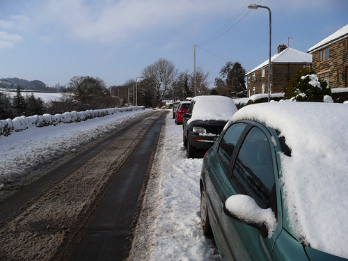
Being a part-time worker has it's advantages and meant that I could go out for a walk instead of struggling into the office in Sheffield.
Subscribe to:
Comments (Atom)

