Showing posts with label aerial photos. Show all posts

Saturday, 6 March 2010

Young Geographers Go Local

A new set of resources to help you teach about your `Local Area' is now available from the Geographical Association website.


There are lots of ideas here to help you get started with using ICT and digital mapping in the context of your school grounds and local area.  I chose to focus on how children `felt' about their local area in order to engage them directly with their `everyday geographical experience'.  Please don't be put off by the `online cpd' label on the GA website - these are all practical ideas that have been shared elsewhere on this blog.

Access this resource at: Young geographers Go Local

A view from the top!


We went up on the Sheffield `Big Wheel' yesterday for the first time as we felt the weather was quite good. The aerial photos are on Flickr - not great images as the light was dodgier than I thought and the perspex exterior of the carriage was badly scratched.


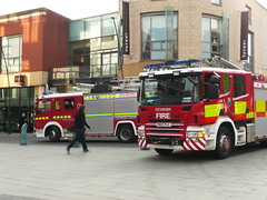
There was a whole lot of drama around Coles (John Lewis) (yesterday) with fire engines as well as a BBC mobile unit (which was on the spot by sheer coincidence). Apparently there was a small electrical fire in perfumery - info courtesy of the Sheffield Forum where you can find out much you want to know and very definitely a whole heap that you never needed to know - especially from anonymous writers.


Wednesday, 20 January 2010

NASA UK Snow map and Climate Change


I've just read this blog post from Robin Butler on the Ashden Directory Blog site.  It focuses on all of the interest generated around climate change by the recent publication of the NASA snowmap.  It's well worth reading.  You can access it on the Ashden Directory >>>> 

The Ashden Directory is a new find for me and well worth reading.

Sunday, 10 January 2010

UK snow 2009 - field boundaries tessellate in the landscape below.


Snowy landscape, originally uploaded by wendyn56.
Taken on a BA flight from Manchester to Heathrow - see previous post.

River Thames - photographed on flight from Manchester to Heathrow


River Thames, London, originally uploaded by wendyn56.
We leave Crane Moor at 5am, black ice shining in the orange glow of the street light as we set off across the Pennines. Arriving in Manchester we find rain.

Flight from Manchester to Heathrow

Soggy greens and browns appear as we take off … quickly followed by field patterns that tessellate black and white below.

Twenty minutes into our journey the River Thames comes into view and familiar London landmarks appear below.

Finally we arrive at Heathrow airport – Terminal 5 where flashing screens and pink butterflies distract us while we wait.

(These photographs were taken in February 2009 en-route to India. They form part of the India collection that I'm slowly uploading to Flickr. I thought that teachers might find them useful as some of them show field and settlements patterns in the snow below. There are also some very useful images of landmarks along the River Thames.)

Friday, 30 October 2009

Finding high quality images for geography

I prepared this PowerPoint for my seminar at the TES Education Show in London (02/10/09) and then decided that I didn't have time to share it - so I've chosen to share it here instead.

Monday, 18 May 2009

Dual Maps


Dual Maps is a stunning combination of StreetView Google Maps and Virtual Earth. Thank you to Noel Jenkins for sharing this website. I think it's great!