Monday, 28 January 2008

Reflections on a Primary Cross-Curricular & Creativity Conference

On Friday 25th January I took part in a conference for a pyramid of Wakefield schools. What follows are a few of my thoughts linked to the keynote presentation.


The first thing that strikes me is the influential role of some of the independent educational consultancies in shaping the direction that primary schools take when reviewing their curriculum. In this case our conference was led by a well regarded keynote speaker from a prominent commercial education consultancy. I heard some conflicting messages.

Some were excellent, i.e. we need to provide `hooks’ at the beginning of a new (topic/ unit/ theme/ project) to ensure children engage with the learning; use questions to focus learning; engage with the local area; help children to make connections about their learning experiences so that they are joined up and make sense in their minds; provide opportunities for pupils to share `what they know’, e.g. through making a video to show to other children in the school.

While others messages appeared muddled, i.e. the synonymous use of literacy/ English and numeracy/ mathematics; the use of sub-grades in subjects such as geography (what exactly does a 5c look like?) and very definitely the Primary School Year 3 planning for geography, `How will Global Warming change my life?’

[I want to return to two of these areas, i.e. the ones that relate to assessment in geography and to Global Warming in a later entry.]

So, do the solutions to the primary curriculum lie with the published advice and guidance that commercial educational organisations provide or do the solutions lie with teachers in the classroom who know their pupils and want to provide a curriculum that starts with the child and takes into account the needs of the child and the community in which the child grows up?

Wednesday, 23 January 2008

Books & websites for developing an understanding of Global Citizenship and Education for Sustainable Development

It was great to meet so many enthusiastic teachers at yesterday's Quality Geography Conference in London.

One of the things we discussed was using books as starting points for learning in geography and I offered to make a book and website list available through this site. Click on the link below (green text) to access a WORD document which lists a selection of books and websites on the theme:

Global Citizenship and Education for Sustainable Development


Sunday, 20 January 2008

Young Geographers - access to Word documents


The Word documents that were shared on the first day of the Young Geographers Project in Sheffield can be accessed by clicking on the highlighted link.

See below for access to PowerPoint presentations from the day.

Saturday, 19 January 2008

Planning with `big ideas'

The focus for the second session of the `Young Geographers' project was `Planning with `big ideas' or key concepts. (See below for the introductory post on this subject.)

Currently KS3 are being asked to focus their planning for geography around key concepts. Paula Owens (my job share partner) and I have been thinking about whether a similar approach could be useful in the primary school. We believe that the use of `concepts' as a planning tool might help ensure that geography does not disappear from the curriculum if schools move towards cross-curricular approaches to learning.

The first half of the presentation exemplifies the idea of planning from key concepts or `big ideas.

The second half of the presentation shows `Living Geography' in action in school.

The last three slides provide guidance for project members on the format for writing up their materials to be included on the GA project page - Young Geographers

Primary Young Geographers Project

Via funding from the TDA we have been able to offer a new pilot project called `Young Geographers'. Two project groups are currently running, one in Canterbury (course leader Paula Owens) and one in Sheffield where I am course leader. I'm using this blog page to share ideas from my project group.

Additional information will be shared via the main GA project page website:

We had a very succesful first day yesterday which helped to get the project off to a very positive start. Through the project we are empasising four main elements:

· Engaging in practical 'curriculum making'

· Capturing the sense of motivating 'living geography'

· Learning Outside the Classroom

· Education for Sustainable Development

My introductory presentation was designed to promote reflection on what we might mean when we talk about `Living Geography' and what kinds of activities teachers are using to develop this approach in the primary classroom.

View `Living Geography' presentation.


The notes that follow may help you to make sense of some of the thinking that went into the presentation:

  • Who am I? Why focusing on `identity’ is a valuable place to start when thinking geographically.

· The link between place and identity, i.e where we grow up is a key factor in shaping our identity

· The importance of engaging young people with their own place and supporting them to explore their feelings about the place – Quikmaps example, Wakefield. Internet mapping that directly allows an exploration of place and space.

· Involving young people in `changing places’ – the importance of feeling that you can make a difference to your community, learning how change happens, what’s involved, making change happen (making learning real - not just another `school' activity)

· The importance of geographical imagination to the way we think about `place’ – location, first hand-experience, the way the world is represented to us and our emotional response to places are all important factors in shaping our geographical imaginations. Actual journey’s (fieldwork) and virtual journeys (role-play, drama, imaginative engagement with photographs) are valuable classroom activities that both inform and extend our geographical imagination.

· Discussions with others can help us to re-think the way that the world has been represented to us - `What image comes into your head when you are asked to think about Iran?’ [P4C can be a very supportive classroom strategy.]

  • Our concluding slides ask you to think about `school geography’ and experience of geography in our everyday lives – which kind of experience do we want for the children we teach?

Saturday, 1 December 2007

Emoting with maps!

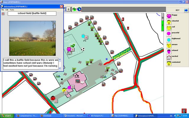
The emoticon icons used with the Local Studies programme were drawn by the children and then re-created using the programme Symbol Draw. Unfortunately this programme (or at least the version I possess) is feeling a little dated now and I was unable to import pre-scanned images. Instead I had to re-draw each symbol using the simple draw tools provided in the programme.

My next step will be to explore using the children's icons with Google `My Maps' as I know it is possible to import new icons from scanned jpeg files into it.

Emoting with maps!


I’ve just completed my fourth and final session of the Autumn Term with Year 5 at Methodist J & I. This week we learnt how to add text to their Local Studies map and how to add the hotspots which display text and pictures.

One of my aims for this project has been to try and tap into the children’s `geographical imaginations’ by providing them with an opportunity to express how they feel about different parts of the school and grounds.

Well worth reading is an article entitled `Emoting with maps!’, which was written by Diane Swift for Issue 27 of the Ordnance Survey Mapping News. Diane argues convincingly that we should be using mapping as means of exploring the personal geographies inside children’s heads.

“If this geography remains in the head of the learner, it is an educational opportunity lost. If pupils’ geographical imaginations do not find a forum within which they can be shared, developed, refined, critiqued and reviewed, misconceptions may go unchallenged and pupils’ learning become restricted in certain ways. ... Using maps and cartography is one medium into which emotions can be poured. Annotating conventional maps or creating the pupils’ own maps are purposeful activities. Through these activities the geography in our heads, our emotional geography, is revealed. Once revealed it can be used, analysed, and reviewed.” Diane Swift, (2004) p.12, Mapping News Issue 27 Winter 2004, Ordnance Survey

The majority of children have now completed their Local Studies maps. Use of the Local Studies programme has enabled the children to represent their school grounds and the immediate local area creatively and imaginatively. Not only are their maps a real pleasure to look at they are also highly informative about what it `feels’ like to be in certain places. As I write this I’m left wondering about the extent to which some of these messages will prove to be a revelation to the staff of the school.

“… exploring a representation, constructing an argument using cartography is challenging and yet accessible to all. My own children in their reception and pre-reception classes are well used to the happy and sad face in their classroom. Their names are places on the face that best shares the teacher’s view of their behaviour. They can then transfer these familiar symbols, with relative ease, to a simple map or photograph to explain their geographical imagination of a place. Happy is, of course, used to symbolise the treasured places. This map is then used as a resource to support an informed conversation as to why they hold that view of that place, and to see if that view is shared. From there we explore if that view is reasonable, and if not gently challenge the perspective with reasoned alternatives, using geographical information. Through conversation geographical thinking is being refined and the quality of this thinking is raised.” Diane Swift, (2004) p. 14