Saturday, 24 November 2007

Hollinger in Antartica


Ruth Hollinger, a teacher from A Sheffield school is currently on an expedition in Antartica. She has created a blog called Hollinger in Antartica so that students back in school can follow her exploits.

Ruth is using Edublog rather than Blogger as it is more secure when creating content for pupils.

`Curriculum Making' using ICT


One of the things that I've found when working with my Y5 group is that they need lots of opportunity to actually draw their maps and use the drag and drop features of the software.

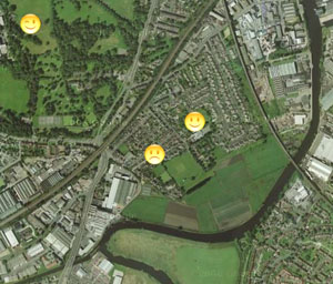
An internet based programme that I've also been using to explore the children's local area (and one that will zoom out to the wider world) is called Quikmaps - the children have loved being able to zoom in really close and see the detail of their local area.


We have been using the Hybrid view which allows us to see the aerial photograph + some street names.


Not all areas of the world will be displayed at the same resolution. I think we are quite lucky in south and west Yorkshire that the Google aerial imagery is high resolution which means we can see lots of detail on the ground.

Next week I am going to get three children to create a similar Quikmap of their local area based on the children's `feelings' about their own locality. They will gather statements from the other children in the class and compile a class map while the rest of the class are completing their Local Studies project of the school grounds.

I've also been experimenting with My Maps - which is a customizable version of Google Maps (in fact both programmes use Google Maps). The advantage of My Maps over Qickmaps is that you can easily link photographs from an online photo-gallery. See Thornes area of Wakefield


In order to incorporate photographs you need them stored on an online gallery. I use both Picasa (Google) and Flickr (Yahoo).

My online photo galleries are at:

http://www.flickr.com/photos/primarygeography/sets/

http://picasaweb.google.com/Wendyn57

http://picasaweb.google.com/wendyn549

Friday, 23 November 2007

Mapping Places: Using Local Studies


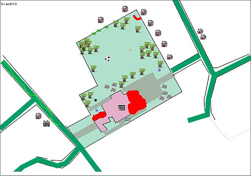
I've recently introduced the software mapping programme `Local Studies' to some pupils at Methodist J & I Primary School in Wakefield. I'm also currently delivering the primary ICT component on the Action Plan for Geography (APG) Curriculum Making Events and this work with children is providing me with very valuable learning experiences that I can share with teachers on the course.

Children are finding the software very easy to use and have produced some interesting maps to show how the school building and grounds are different to the aerial view & map that we viewed using Quikmaps.

For example the school building is now much longer than the view shown on Quikmaps because of the new nursery and offices on the North East end of the building. The idea that maps and aerial photographs can be inaccurate is useful learning for children as it enables us to talk about how they are only a record of a particular moment in time.
(Quikmaps uses Google Maps)

Local Studies is the only mapping programme that I know that integrates a drawing package with drag & drop symbols. This makes it a very useful piece of software and it can be used from Foundation Stage through to KS3.

However, teachers do find the different ways of saving the programme confusing at first as it can be saved as both a `project' and a `background map'.

Though the children have enjoyed using Local Studies we experienced real difficulties on our very first session as we couldn't save any of the work that the children produced. We asked the school ICT technician to find a way round our difficulties (this was linked to the way that the network is set up to save children's work into their individual folders). We now have a separate folder into which we can save their work.

This problem linked to saving to networks is one that other schools have experienced and I wonder if Soft Teach could help a little more by providing better advice about using this programme on school networks. [There is advice on the CD-Rom - but this did not solve our difficulty.] The programme has been around for some years now and I wonder if it is quite keeping up with changes in technology.

Thursday, 17 May 2007

Quikmap - Whittingham School visit Seahouses

This is my first experiment with creating a map using Quikmap. I have based it on the walk that the Year 4 children from Whittingham Primary School In Northumberland made from the Seahouses Hostel to the seafront in April 2007.


www.quikmap.com

Monday, 7 May 2007

Seahouses Harbour - Collage created using Picasa

Click here or on the image to be taken to the Seahouses website

I've recently begun to use the Picasa photo-gallery from Google and am very taken with. It has many very useful features, including a time-line that lets you find images according to the date they were stored on the computer. It also has some very useful image editing tools (my only issue with the programme is that there is no re-sizing tool). Web-galleries can be created and shared with contacts via e-mail. The whole package is interlinked to both Google Earth and to Blogger, which makes linking into the Google suite of programmes very easy. I particularly like how both Picasa images and Quickmaps can be viewed in Google Earth.

Thursday, 7 December 2006

Meeting with Wakefield Primary Geography Coordinators


I would like to say a big thank you to the 15 Wakefield Geography Coordinators who attended yesterdays meeting about school self evaluation and the use of the Primary Geography Quality Mark. The meeting was very enjoyable and people contributed with great enthusaism. It was good to catch up with so many friendly faces.


Looking ahead to the next meeting, on the afternoon of February 14th at Woolley Hall, teachers identified aspects of geography that they are working on now and things they would like to work on next. I thought I could share their ideas through this blog. There seems to be two core groups of interest - those who are focused on developing policy, reviewing schemes of work etc. and those who would like to focus more on cross-curricular approaches and making sure the curriculum is more creative and fun. These do not seem to me to be mutually exclusive and it would be good to try and think how these link together in our next session. If anyone would like to contribute to this discussion - please post your comments below.


What are you working on now?
Developing the use of the Outdoor classroom for KS1
Exciting ideas for IWB’s
How to record monitoring of planning & children’s learning
Review policy & SoW using PGQM – use key indicators to audit with members of staff
Build up appropriate resources
Finalising geog policy for amalgamated school & reviewing resources
Curriculum review – allocation/ re-allocation of topics and resources
Trying to give geography a higher status – reclaim it as part of a broad & balanced curriculum.
Make it fun & exciting.
Develop cross-curricular themes.
Promote Speaking & Listening, use more role-play
Free up time to spend on Geog.
Extend resources
A file of places to visit in Yorkshire
Review geog policy
Audit resources
Skills based learning
Develop a more creative/ cross-curricular approach in KS1
Raising standards & attainment (Core?)
Skills/ fieldwork
More flexible approach – linked to other subjects – making geog fun
Investigations in geog, higher order thinking, G & T in Geog

What are you keen to work on next?
An outdoor maths trail
Update policy
Monitor effectiveness of geography in school
Scrutiny of work + Lesson observations and evaluation
Develop a ` World Week’
Update resources and teaching materials
Develop local aspects of hist/ geog
Use school facilities to enhance geog curriculum
Cross- curric initiatives
Subscribe GA
Meetings with colleagues
- discuss/ develop geog teaching
- scrutinise & level work
X-curricular opportunities
Creativity theme weeks etc


Wednesday, 6 December 2006

Everyday Geographies


Over the last month I have been writing a contribution for the Primary Geography & ICT section of the Geography Teaching Today website - the full text should appear on the web in late December/ early January. I have become interested in thinking about how we use our everyday experience of the world to engage children in geographical learning. The following extract is a quote from the materials that will appear on the GTT website.

Everyday Geography
An exciting and meaningful debate is currently taking place within the geography community about whether we engage effectively with our own and children’s everyday experiences of the world. If you read Primary Geography (Autumn 2006) you might have seen Fran Martin’s article entitled `Everyday Geography’. I would like to use this article as a starting point for reflection on what we teach in primary geography and how we can make this more meaningful for pupils.


In the article, Fran describes an activity that she carries out with her students. This is something that you might want to try now:

`Sit and think for a moment.

If you remember the geography you were taught at school what comes to mind?


Now think about the geographical experiences you have in your everyday life.

How did your own experience compare with Fran’s?

How often do you start from either your own experience of the world or from the children’s direct experience of their world?


Find out more … If you are a member of the GA you will have the Autumn edition of the magazine in which the article appeared. When the full version of this distance learning material appears on the GTT website you should be able to download a pdf copy of the article from the web.

http://www.geographyteachingtoday.org.uk/